
What would be a trip to Iceland without at least one stop at a waterfall? Well, that would probably be impossible! Take any road to the countryside and you will more than likely see streams of water dropping off a cliff. In the country of Fire and Ice, waterfalls are in fact, the most common natural wonder you will come across. While there are hundreds of them across the country, we have listed the Best waterfalls that are easily accessible.
When we say “easily accessible”, we mean they are close enough to the main Ring Road 1, and getting there involves a very little amount of walking.
The good news is that the best waterfalls in Iceland are really accessible! Some are even only a couple of hours from Reykjavik which is perfect for a day trip. If you are organising a road trip in Iceland, you will more than likely come across them all.

Best Waterfalls in Iceland
MAP OF The Best waterfallS IN ICELAND
To help you find your way, we have created the Map below of the best waterfalls in Iceland described in this article. You will find their exact position and the closest car park available. If you think we have missed anything, let us know, and we will add it to the map.
SAVE OUR MAP – 10+Incredible Waterfalls in Iceland
You can download our Iceland Itinerary map. To do this, click on the star (right next to the title) – It will be saved in your Google Maps > Your Places. You can use this map offline during your trip. Click on the pin to see a photo and name of the place + link to websites if any.
You can also download in “KML” and import in Maps.me (which in our opinion, is a lot easier to use offline than google maps.)
Oxararfoss waterfall

First on our list is Oxararfoss waterfall because it is the closest to Reykjavik and one of the first stops on the popular Golden Circle route. Located within the Thingvellir National Park, the 20m high waterfall jumps off the Almannagja canyon on the west side of the Mid-Atlantic rift ridge. It is believed the river Oxara was diverted into the rift about 1000 AD to sustain in water the people flocking to the park for the Alping (yearly assembly of regional chieftains).
The waterfall is one of the main things to see while visiting Thingvellir National Park. It is only a 5 to 10 min walk from the car park (depending on which one you stopped at) and easily accessible through a nice boardwalk. Be mindful closer to the waterfall as the wood may be a bit slippery.
A little bit downstream of the river, there is a nice waterfall you can see from the trails below. There is also a large pool that was used during the 17th century for punishment (women were drowned and men were beheaded). You can see the place on your way to the visitor centre & viewpoint (south of the park).
Meaning: Oxararfoss means the “Axe falls”.
Entrance: Free – Car Park = 1,000 ISK
On the Map: Clear Blue dot – Coordinates: 64.26588, -21.11712
Take a tour from Reykjavik: Golden Circle and Waterfalls Small-Group Tour
Gullfoss waterfall

Also located on the Golden Circle Route, Gullfoss is one of the most popular waterfalls in Iceland. Fed by the mighty Hvita river which begins at the Hvítárvatn glacier, Gulfoss is very impressive due to its size and strength – especially in Summer, when the glacier upstream is melting.
Gulfoss waterfall is also remarkable for its shape as it first drops by 11 meters through a sort of large staircase before plunging into a 20-meter high crevasse to finally disappear into a canyon. From the multiple viewpoints accessible from the car park, you can see all the different stages of the fall.
Due to its power, the waterfall is always covered by a lot of mist and droplets which fill the canyon with rainbows when the sun is shining! One of the best places to see them is the rocky platform that is the closest to the river. Be extra careful because the wet rocks can be unsafe.
Meaning: Gullfoss means the “Golden falls”.
Entrance: Free
On the Map: Burgundy dot – Coordinates: 64.32707, -20.11994
Take a tour to see Gullfoss, the Golden Circle and Kerid Crater
Seljalandsfoss waterfall

Seljalandsfoss waterfall is found on the south coast of Iceland, about 90 min drive from Reykjavik. You cannot miss it. The water stream is so tall, 60 metres high, it can be seen from the ring road. This giant waterfall is extremely popular and one of the tourists’ favourites for its size and the fact you can walk behind it! Despite not being a typical stop of the Golden Circle, most tours add the waterfall to their itinerary.
You can visit the waterfall any time of the day but it can get very busy with tour buses from mid-morning to mid-afternoon. Try visiting for sunset if you can, depending on the season, you can see the sun through the waterfall when you are behind it (usually in April/May & July/August).
The waterfall is easily accessible by car or with a tour. The path is large and flat for the most part but if you want to walk behind the waterfall, be aware the trail gets muddy and you will need to climb through wet rocks on the left side. Also, you will surely get wet, but what would be a visit to a waterfall in Iceland without ending up soaked?!
In winter the path behind Seljalandsfoss is usually closed because of the icy condition making it too dangerous. Although, it is still worth visiting on short winter days. You might even witness northern lights right above it!
Meaning: Selajandsfoss means “selling the land of waterfalls”
Entrance: Free – Car Park = 700 ISK
On the Map: Orange dot – Coordinates: 63.61562, -19.98856
Join a full-day tour to walk behind the waterfall at Seljalandsfoss and visit the south coast
Gljúfrabúi waterfall


Gljúfrabúi waterfall is a hidden gem located in a gorge only 500 m from Seljalandsfoss. Not visible from the road or even the path, most visitors don’t venture this way and usually miss it. When you visit Seljalandsfoss make sure to also stop at Gljúfrabúi. The experience of entering the gorge and discovering the waterfall at the back is in itself a highlight!
There is a large flat path on the left of Seljalandsfoss waterfall that will bring you to the entrance of Gljúfrabúi gorge. You can see the waterfall from the entrance of the gorge, but it is really worth going inside too. To do so, you will need to follow the canyon wall on the right for about 10 meters. Depending on how high the little river is, your feet might get wet.
Meaning: Gljúfrabúi means the “inhabitant of the gorge”
Entrance: Free – Car Park = 700 ISK (same as Seljalandsfoss – no need to pay twice)
On the Map: Orange dot – Coordinates: 63.62086, -19.98644
Skogafoss waterfall

Skogafoss is our one of our favourite waterfalls on the South Coast of Iceland. Wide and powerful, it offers incredible photo opportunities to those who like playing with perspectives and water reflection. On sunny days, you can also see one or two rainbows forming at its bottom. It is a truly picturesque place to hang out and enjoy the power of nature.
Before reaching the waterfall, there are stairs (a bit wobbly and steep, so take extra care) leading to a viewpoint above Skogafoss. It is worth going up if you can, for a vantage point of the fall but also the valley.
From this lookout also starts the Fimmvörðuháls hike to Þórsmörk. Along this 25km long trail, there are more than 25 waterfalls. However, without hiking it entirely, you can already find a few breathtaking waterfalls and cross gorgeous landscapes within a couple of kilometres. The trail is mostly flat and well-marked. Allow 30 min to 1 hour return to truly experience this area.
Meaning: Skogafoss name comes from the Skogar river – Skogar literally means “forests” in Icelandic.
Entrance: Free
On the Map: Yellow dot – Coordinates: 63.53205, -19.51137
Stop at Skogafoss on your way to Jökulsárlón Glacier Lagoon with this highly recommended day tour from Reykjavik
Pss!!! Want to learn about a hidden waterfall near Skogafoss? Kvernufoss is a beautiful waterfall that not many visitors know about. Located near the Skogar museum (on the far east side of the parking), this waterfall is a lot less crowded than most of those listed here… and you can walk behind it!!
On the Map: Green yellow dot – Coordinates: 63.5283, -19.4810 Entrance: Free but car park 700 ISK


MUST READ! Top Day Hikes in Iceland
FOSS A SIDU waterfall

You won’t find many details about Foss a Sidu in travel guides, however, if you drive along the Ring Road from Reykjavik to Jökulsárlón Lagoon, you can hardly miss it! Foss a Sidu is in fact, located about 15 km after Kirkjubæjarklaustur and is a beautiful place to stop for a quick break. There is a small car park that fits a few cars but the waterfall itself is not accessible up close as it is part of a private farm.
Nevertheless, Foss a Sidu is best appreciated from far away anyway, whether it is from the Ring Road itself or from the rock formations of Dverghamrar found a couple of kilometres down the road. Both places offer scenic views of the 60 meters high fall, the gorgeous black cliffs it drops from, and the farm below.
Meaning: Foss a Sidu takes its name from the cliff it falls from called “Sidu”.
Entrance: Free
On the Map: Green dot – Coordinates: 63.85551, -17.86897
Svartifoss waterfall

Located in the Skaftafell Nature Reserve, Svartifoss waterfall is accessible via a 30-min hike. The trail is a bit steep but it passes through a couple of viewpoints overlooking several waterfalls. The most spectacular waterfall along the trail is definitely Svartifoss. This beautiful water stream drops from a black cliff formed by hexagonal basalt columns. One of the main types of rock formations in Iceland. It is so impressive, it even inspired the architect of the main church in Reykjavik, Hallgrímskirkja.
Getting to Skaftafell waterfall is quite easy and an absolute must-see if you plan to drive Iceland’s south coast towards the Vatnajökull National Park. It is only 5 min off the Ring Road and you will find a campsite as well as a tourism office. You can ask for a map at the tourist centre and extend your stay by also hiking to the Sjónarnípa viewpoint.
Meaning: Svartifoss means the “black falls”
Entrance: Free – Car park 700 ISK
On the Map: Petrol dot – Coordinates: 64.02752, -16.9753
During your stay at Skatafell, visit a natural blue ice cave and walk on Vatnajökull glacier
SELFOSS & DETTIFOSS waterfallS

Dettifoss and Selfoss are two famous waterfalls in the North of Iceland. Both are located within the Jokulsargljufur National Park, along the Jökulsá á Fjöllum river. You can visit both at the same time.
Dettifos is the most powerful waterfall in Iceland (and the 2nd in Europe) with a flow of almost 200 cubic meters per second. The roaring sound of the water is very impressive and can be heard hundreds of metres away. Selfoss on its side is a lot quieter but nonetheless spectacular with its 100 meters wide and 11 meters high.
To visit these beautiful waterfalls, you will need to drive about 30 min north off the Ring road. There are two viewpoints around Dettifoss but they are both accessible from different roads (862 or 864). Going from one car park to the other takes about a 1-hour drive.
If you don’t plan on visiting both parts, we recommend the viewpoint on the west side which is more accessible and has better infrastructure. Moreover, the access to the east side is on a dirt road which can be challenging. If you choose the west side, you can then hike for 10-15 min to Selfoss. The trail is well-marked and follows the river.
If you wish to continue and explore the area a bit longer, you can also drive up to Hafragilsfoss. There is a dirt road a few hundred meters back on the road after you leave the Dettifoss West car park. This is not an F-road but do remain vigilant. Hafragilsfoss waterfall can also be seen from the east side. The turn is 3.5km after the Dettifoss east side car park.
Meaning: Dettifoss means the “collapsing waterfall”
Entrance: Free
On the Map: Fuchsia dot – Coordinates: 65.81466, -16.38457
Join a 6-day tour for a full circle around Iceland. You will get to see a lot of the waterfalls, Dettifoss included
Godafoss waterfall
Also found in the northern part of Iceland, Godafoss is a very quick stop along the “Diamond Circle“! It is located 45 min west of Mývatn and 40 minutes south of Husavik. The waterfall can get very crowded during summer because of its close proximity to the Ring road (100 meters). Visiting early in the morning or later at night might be a good option. We love this wide horse-shoe-shaped fall because it is as imposing as it is dramatic.
There are also a few viewpoints within walking distance from two different car parks. However, you do not need to take the car to go from one side to the other. There is a pedestrian bridge nearby the gift shop, you can cross to reach the other side. Overwise, you can park on one side and then drive to the other. In our opinion, the east side offers the best panorama, but both sides are worth a visit.
Meaning: Godafoss means the “waterfall of the Gods”
Entrance: Free
On the Map: Brown dot – Coordinates: 65.68277, -17.55019
OTHER waterfallS IN ICELAND
Here is a selection of several waterfalls found in Iceland that are less accessible but couldn’t be missed in this listing. They are mostly in secluded areas and require either a 4WD or hiking for at least a couple of hours.
Haifoss waterfall

Haifoss is one of the tallest waterfalls in Iceland (122m). Found in the Thjorsardalur Valley on the southern side of Iceland it is a nice detour to add to your Golden Circle itinerary if you have access to a 4WD.
The road to Haifoss is not an F-road but the gravel road can be in very bad condition depending on the time of the year. It is not recommended to drive up there with a 2WD.
From the car park, it is only a 5 min walk to the viewpoints. There are also a few hiking trails if you want to go to the bottom of the fall or see other waterfalls in the area like Glanni waterfall.
Meaning: Haifoss means “high waterfall”
Entrance: Free
On the Map: Purple dot – Coordinates: 64.20788, -19.68685
Take a super Jeep tour to Landmannalaugar (the pearl of the Highlands) and stop at Haifoss waterfall
Glymur waterfall
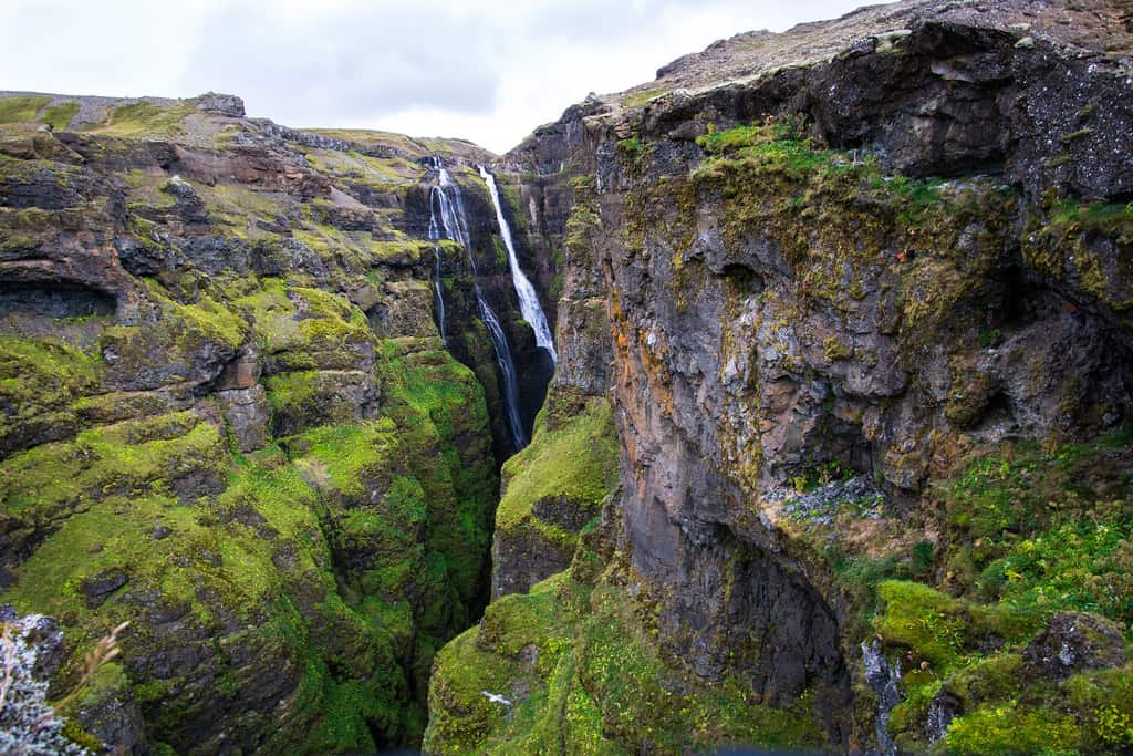
Glymur waterfall is 198 meters high, which makes it the 2nd highest waterfall in Iceland after Morsárfoss (near Skaftafell). It is located only 70km from Reykjavik but it requires hiking for a good 2-hour just to get there. While the access isn’t that easy, it is nevertheless a good day trip from the capital if you are an avid hiker.
This day hike is quite strenuous and involves crossing rivers on a wire. Most people prefer hiring a guide or taking a tour. Though the scenery is extraordinary and well worth a shot if you are fit and have the equipment!
Meaning: Glymur means “rumble”
Entrance: Free
On the Map: Dark Blue dot – Coordinates: 64.39167, -21.25057
Hengifoss waterfall
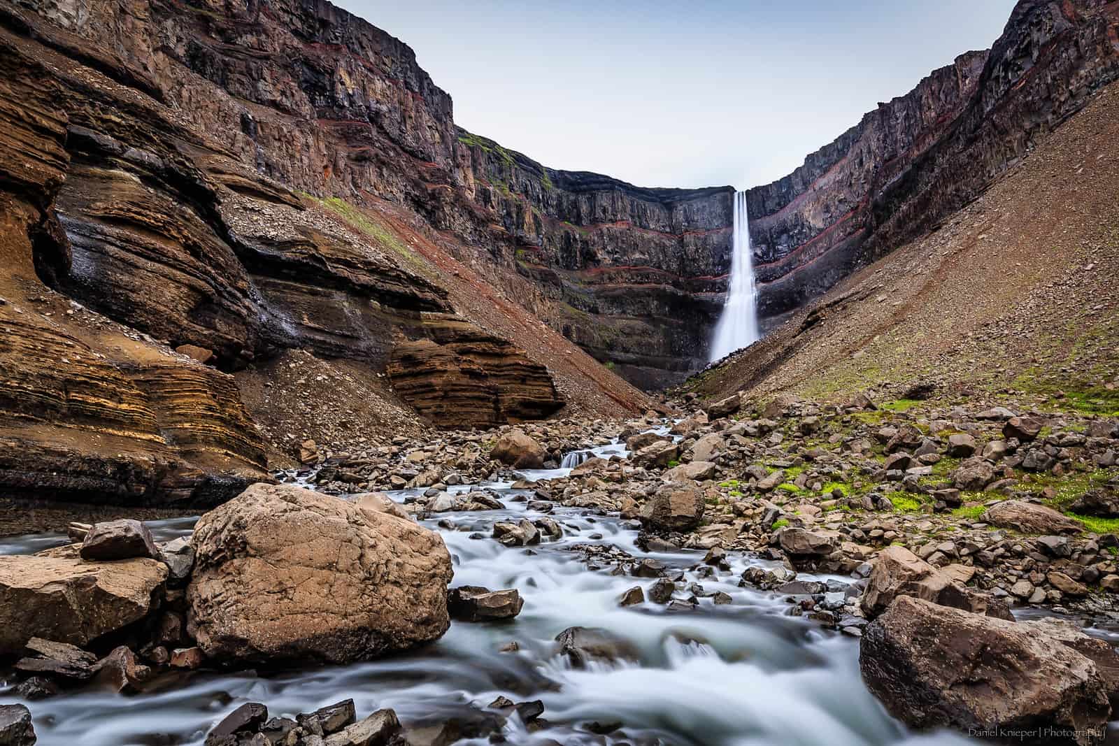
Hengifoss is quite unique and arguably the most beautiful waterfall in the eastern part of Iceland. With its 128 metres drop from a high plateau and the red rocks layered within the basalt cliffs, Hengiffoss tends to be quite popular in summer. To get to the fall, you will need to drive about 30 min from Egilsstaðir and hike up 2.5km one way.
Despite this walk, we still believe it is fairly accessible compared to other places in Iceland. The trail is well-defined and there are several benches along the way. Despite being uphill for its majority, the surrounding landscapes and several other waterfalls (such as Litlanesfoss) make it a well-worth workout. However, make sure to wear appropriate hiking shoes; there can be several sections where you have to walk through streams.
The trail ends on a platform with a good view of Hengifoss. If you are visiting in the winter you will more than likely have to bring crampons and poles. It is not recommended if you aren’t equipped.
You can read more about the best day hikes in Iceland (including Hengifoss) in this article.
Meaning: Hengifoss means the “hanging waterfall”
Entrance: Free
On the Map: Clear Gray dot – Coordinates: 65.09567, -14.88958
Bruarfoss waterfall

Bruarfoss are a lot smaller than all the other waterfalls described until now, however, it is definitely a must-see during a trip in Iceland. Bruarfoss waterfall is actually right on the Golden Circle route, but due to its secluded location, few know about it or venture to see it.
To get to the fall, you will need to park on the side of road 37 (there is a car park- see map) and then hike about 3.5km one way on a fairly easy trail. Even if it isn’t exactly well-mark in some parts, you can find your way without any issues. If you are unsure, we always recommend using maps.me app. It has the trails mapped and can be used offline.
You will pass a couple of small waterfalls (Hlauptungufoss and Miðfoss) before arriving at a wooden bridge overlooking Bruarfoss. It is one of the best places to see it. But you can also walk below to reach the river. You will notice how blue the water is!
Meaning: Bruarfoss means the “bridge waterfall”
Entrance: Free
On the Map: Dark Gray dot – Coordinates: 64.26425, -20.5157
ARE YOU PLANNING A TRIP TO ICELAND?
We have a lot of articles about travelling in Iceland and add new ones each month. Check out our latest guides below to prepare for your trip…
- 10+ Must-See Waterfalls in Iceland
- Best Day Trips from Reykjavik
- Self-Drive Guide to the Golden Circle
- 5 Beautiful Black Sand Beaches
- Top Day Hikes in Iceland
- Iceland on a Budget
- Exploring Vatnajokull National Park
- 7-day Road-Trip Itinerary to the South Coast
- 10 best hot springs in Iceland
Please note │ This blog post may also include affiliate links to hostels or products we recommend, which means if you buy something following a link on this page, we’ll get a small commission. This will be of no extra cost to you but will help us continue running this blog. Thank you for your support.

ARE YOU ON PINTEREST?
What about saving this post to your Pinterest board?
Click on the photo to save this blog post about the best waterfalls in Iceland for later. We are also on the platform and we love pinning great travel tips. Follow Tales From The Lens’ boards to see our latest pins.
Don’t be shy, come say hi!

About the Author
Jen is the Funder, Author & Photographer behind Talesfromthelens.comJen has lived for the past 15 years across Oceania and Ireland while also travelling in Latin America, North America, and Europe. She has visited more than 65 countries and set foot on every continent in the world! She is a coffee nerd, passionate about photography, wildlife, and outdoor activities.
For more info, check out the About page.
I love all of these recommendations – I can’t wait to get back to Iceland. I’ve seen almost all of these but I want to do it all over again!
Should we organise a trip?! I am dying to go back in 2022.
I love and adore waterfall hikes so I’d love to check all of these out someday! I haven’t had a chance to go to Iceland yet but it’s definitely on my list!! Your photos are beautiful!
Thank you Farrah. If you like waterfall hikes then you MUST do the Fimmvörðuháls hike to Þórsmörk!! 25km and more than 25 waterfalls :O
All I want to do in Iceland is chase waterfalls, looks absolutely stunning! Definitely saving this article for when I go, thanks heaps for sharing
Would you rather not “stick to the rivers and the lakes that you’re used to”? 😀 😀
Omg this makes me miss Iceland so much! I did the ring road the last time I was here and saw a few of these, but next time I want to go to the highlands! I wonder if there are waterfalls there….
Hey Kay!! I am also dying to go to the Highlands, planning to go hiking there this summer if everything goes well. There are indeed waterfalls in the Highlands in Iceland but they are just harder to access: Gýgjarfoss, Sigoldufoss, Ófærufoss, Fagrifoss, Sigöldugljufur. (I tried to focus on the accessible ones in this article)